Understanding water flow can be a challenging task. With the record-breaking rainfall events, over the past few years, FBLID 15’s levee systems have shown their strengths as well as areas for potential improvement. To date, the levee has served its purpose successfully by preventing the overflow of the rising Brazos River into FBLID 15.
Since September 2017, efforts have been made to evaluate and increase pumping capacity to minimize flood risk ‘inside’ of the levee. This effort began with FBLID 15 and FBLID 19’s immediate joint purchase of portable pumps to produce extra pumping capacity to serve the Steep Bank Creek Watershed, followed by the acquisition of ‘Gator Pumps’ to provide the additional pumping capacity to serve the Alcorn Bayou Watershed. Also, FBLID 15 is participating in the expansion of the Steep Bank Creek pumping station to increase the pumping capacity. Below are some explanations of components that are evaluated to understand the flow of the water within the district as well as the ability to rid the district of water in an emergency.
What is a watershed?
Answer: an area or ridges of land that separates waters flowing to different rivers, basins, or seas. In particular, to FBLID 15 the watershed is designed to handle storm sewer water flow as well.
- Fort Bend County, in general, has subtle topography, meaning it is generally flat and flows are typically not guided by natural hills or valleys.
- FBLID 15 is located within three watersheds
- All three watersheds flow into the Brazos River (Map A below)
- Alcorn Bayou watershed: Area in orange
- Snake Slough watershed: Area in pink
- Steep Bank Creek watershed: Area in yellow
What is a tributary?
Answer: a creek or stream flowing into a more massive river or lake
- The watersheds listed above are named for the tributaries they surround; Alcorn Bayou, Snake Slough, and Steep Bank Creek.
- Map A below labels these tributaries that flow into the Brazos River
- The Brazos River, tributaries, retention lakes, and ditches are in blue
What is a levee?
Answer: an embankment (a wall or bank of earth) built to prevent the overflow of a river
- Levee systems have been constructed in this area to protect naturally low-lying land from rising Brazos River waters
- A levee system protects homes in FBLID 15
- The levee system protected the homeowners during the last several rain events, including Harvey, by preventing the river from flowing freely in the developed area
- Map B below shows levee boundaries in green
What is a pump station?
Answer: facilities including pumps and equipment for pumping water from inside the levee back into the Brazos River.
- FBLID 15 has a pump station located within Alcorn Bayou watershed, they share the pump station in the Steep Bank Creek watershed, and they are constructing a pump station in the Snake Slough watershed.
Steep Bank Creek
Built In: 4 x 20,000 GPM = 80,000 GPM
Mobile Pumps : 12 pumps with total capacity of 81,000 GPM
Expansion : Built In 3 x 50,000 GPM = 150,000 (under design)
Upon completion of the expansion, the built in capacity will be 230,000 GPM
Alcorn Bayou
Built In: 5 x 30,000 GPM = 150,000 GPM
Mobile Pumps (Gator) : 5 x 8,000 GPM = 40,000 GPM
Snake Slough
Built In: 4 x 12,500 GPM = 50,000 GPM (Under construction)
What new pumps did FBLID 15 purchase after Hurricane Harvey?
- FBLID 15 and FBLID 19 jointly purchased portable pumps to have on hand to provide additional pumping capacity in future events. These portable pumps have a pumping capacity of 81,000 gpm.
- Residents witnessed these pumps ‘in action’ during the recent May rainfall event.
- FBLID 15 and FBLID 19 are also jointly expanding the pump station at Steep Bank to add three new pumps. Independently LID 15 purchased new gator pumps.
What is a “Gator Pump?”
Answer: a portable trailer mounted pump to add additional pumping capacity in high water events
- FBLID 15 has purchased 5 ‘Gator Pumps’
- Each portable pump has approximately 8,000 gpm additional pumping capacity (5 pumps x 8,000 = 40,000 gpm)
The FBLID 15 Board of Directors continues to work together to provide maintenance and expansion as well as an understanding for the protection of property owners. Residents are encouraged to follow Facebook and the FBLID 15 website to stay informed. On the website you can also sign up for text and email notifications for emergency messages.
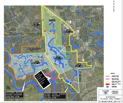
Map A
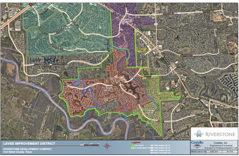
Map B