Weather Update – May 9, 2024

The Brazos River continues to rise and is forecasted to crest at 45 feet in Richmond, Texas by Friday, May 10.

This water elevation is more than 10 feet lower than the record flood during Hurricane Harvey in 2017. High water levels outside the levee have closed the FBCLID 15 flood gates, but water will not reach the bottom of the levee.

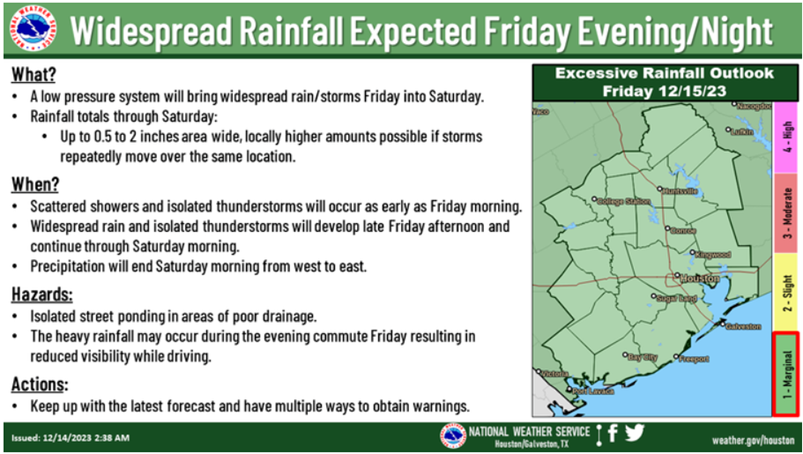
Between Sunday, May 12 and Tuesday, May 14, FBCLID 15 is forecasted to receive 1-2 inches of rain. Fortunately, the Brazos River will begin dropping as rain chances increase.

The FBCLID 15 pump stations and portable pumps have been tested, and operators are on stand-by if it begins to rain.

The latest forecast and information from the National Weather Service is included below:

Project Brazos Update

In January 2024, the City of Sugar Land approved a $28 million grant application to address bank erosion along the Brazos River. Referred to as Project Brazos, the proposed scope includes two large bends of the Brazos River near the LID 15 levee that protects Riverstone. The LID 15 levee and Riverstone residents do not face any imminent danger from the Brazos River. This erosion prevention project will provide long-term protection to Riverstone when the Brazos tries to change course in the future. The proposed design, picture below, was recommended by the United States Army Corps of Engineers and their river erosion specialists at the Engineer Research and Development Center in Vicksburg, MS.

The City of Sugar Land, in cooperation with Fort Bend County and the Texas Water Development Board, will manage and fund Project Brazos in the areas near Riverstone. The City already owns the land between the LID 15 levee and the Brazos River, but LID 15 will need to provide access easements to reach these construction areas outside the levee. Fortunately, access roads already exist for both proposed levee crossings.  The City is currently starting the Request for Qualifications process and hopes to select a design engineer this summer for the Project Brazos areas near Riverstone.

Wetland Maintenance Update

The development of Riverstone required a permit from the United States Army Corps of Engineers (USACE). As part of the USACE permit, the District is required to construct and maintain 25 acres of wetlands. To fulfill this requirement wetland beds were constructed in lakes and parks throughout Riverstone, and an example is pictured below. These beds were purposefully created to help improve water quality in the community’s drainage system.

In late March and April, LID 15 will perform maintenance to expand and improve wetlands throughout the Cypress Bend greenbelt that follows the Club at Riverstone Trail. The existing wetlands are shown in blue on the map below. The contractor will be working in the red areas on the map to expand and deepen the footprint of the wetland beds. To fill these areas, desirable wetland species will be transplanted from other areas of the park and purchased from local nurseries. LID 15 has coordinated this wetland maintenance project with Riverstone HOA, and residents can contact LID 15 directly with any questions or concerns.

Lake Riverstone is the largest lake in the community and contains several wetlands beds. LID 15 recently expanded the wetlands in Lake Riverstone near Wetlands Park. Now that transplanting is complete, residents may notice that Lake Riverstone is not as blue as it normally appears. The wetland improvements are being coordinated with Riverstone HOA and LID 15 requested no additional dye be added to color Lake Riverstone. The lack of lake dye will help ensure the new wetland plants receive enough sunlight while they get established this spring. The dying of Lake Riverstone is currently scheduled to resume in June.

Riverstone Wetland Beds

Riverstone Wetland Beds

Cypress Bend Wetland Maintenance

Cypress Bend Wetland Maintenance